

Mill Lake
Mill Lake is home to a big cliff with some great classic ice routes. It's located just east across Highway 400 from Parry Sound (about 165 km south of Sudbury) on the southeast side of Mill Lake. Take Hwy 69 south out of Sudbury for approximately 130 km until you reach exit 224, McDougall Road. Take this exit and turn left onto McDougall Road. Continue down McDougall for 6 km and then take a left onto Scullion Road (which is mistakenly called Parton Road on some internet maps). Follow this road for 500 meters and park here. Head down the narrow bay, turn left (south) around a point. There will be a cliff down the bay on your left, but this is not the main cliff. Head around the next point (which is actually an island; you can go around it on either side, though shorter to the west). The main cliff will be visible once you go around the island. About a 30 minute walk. The distance is about 1.8 km from the end of the road.
Access
This cliff is private property. This area is closed as the owners do not permit climbing on their land.
Ice Routes
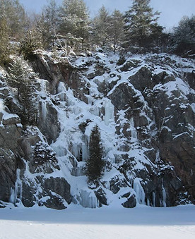
The routes are described from left to right, as you would encounter them when approaching the cliff from the lake.
Unnamed 0 | WI2-WI3+ | 25 m
The first ice flow found furthest left on the rocky point where the wall juts out onto the lake. It starts straight off the frozen lake with a steep vertical step for approximately 6 to 7 metres and then continues up shorter bulges and steps. A much easier WI2 ramp can form up the left side (or you can pull yourself up on an old rope fixed in place here for summer cliff-jumping, if the ice doesn’t touch down - but beware). This route is inconsistent – it does not form every year and bakes out quickly.
Unnamed 1 | WI3 | 23 m
A flow of short vertical steps and ramps, located about 20 m right of Unnamed 0 in a mini-bay. You might wander around a fair bit following the line of least resistance. The start can be thin, and the exit vegetated or mixed.
J-Cubed | WI4 M6 | 18 m
FA Josh Smith/Jon Gullet/Jon Rigg February 15 2013
This climb is found 10m to the left of Unnamed 2. Start up the steep grade 4 corner, move right onto the first cauliflower of ice. A few dry tooling moves will take you through a decent crack and to the upper dagger of ice. For a top anchor, there is a well-placed tree.
Unnamed 2 | WI2-3 | 15 m
A wide, fat flow that spills down the wide gully/slope 30 m left of Ice-olation. It usually forms with a longer, easier bulgy line on the left and very short, easy step on the far right. A steeper column sometimes forms left of center.
Ice-elation | WI 3+ | 60 m
A magnificent line that ascends a narrow notch at the left end of the main cliff face. If the ice does not touch all the way down there are a couple of bolts in the rock on the right to protect a mixed start. Forms consistently.
Waterwings | WI5 | 47 m
FFA Josh Smith/John Gullet/Randy Kielbasiewicz February 15 2013
Climb the buttress via either of the overlaps for a few awkward moves to gain a stance below the lower dollop of ice. Move right under large ice, one thin move to gain main streak. Gear quality increases with elevation, cruise the steep and sustained thin vertical pillar for +/-10 m until it kicks back a bit. Pull bulge through the obligatory Ontario shrubbery. Belay in cave (if doing it in 2 pitches), or continue up slender (12 inch diameter), semi-detached (attached?) pillar, good feet on rock for a few powerful moves to get feet underneath you on the ice. Teeter, totter and tap your way up a bodylength or two, pull bulge through another (smaller) hedge. Continue to top on 4-5 m of easy WI2 rolling terrain or bail from large pine.
Unnamed 3 (Claustrophobia?) | WI3+ | 15 m
The ice that spills down the narrow back corner of the alcove. Can be undermined by flowing water.
Ice-ometrix (aka the Fang) | WI4 | 15 m
Steep stacked pillars on the right wall of a sheltered alcove 50 m right of Ice-olation.

Unnamed 0

J-Cubed
Unnamed 2
Unnamed 1

Ice-elation
Waterwings
